7:40 AM
Early morning thunderstorms moved through Tulsa. I was actually awake looking at the weather models for today. They didn’t really turn severe until reaching Rogers County and remained strong to severe as they moved into northwest Arkansas. At my home in Tulsa, we had some thunder, lightning and little rain.
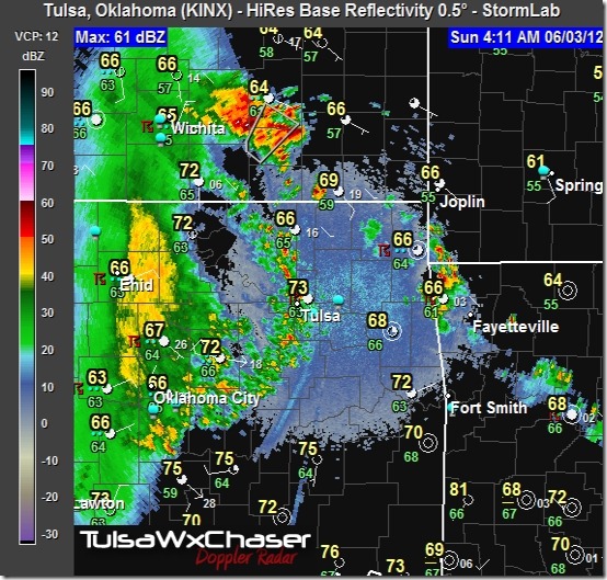
Here’s the radar image I captured as the storms moved through. The most severe in the line of storms was in Kansas. No watches or warnings were issued.
The second band, moderate rainfall around Enid in the image, dissipated before it reached Tulsa. That was a little disappointing. We can surely use the rain.
I don’t think it’s over yet. I’m waiting on the next model update to figure out what’s going on and what is likely to happen the rest of the day.
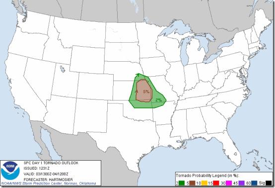
As of now, the NWS is forecasting a chance of rain locally and the possibility of severe storms to the north of Tulsa and in eastern Kansas later today. A tornado or two is possible, but heavy rain, gusty winds and hail are the major threats with any storms that develop.
I’ll post an update once I review the models later in the day.
11:49 AM
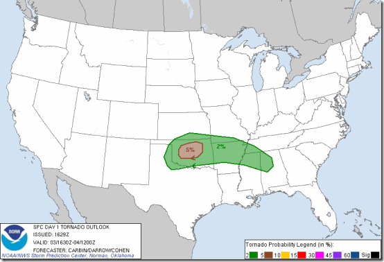
This is a good example as to why I don’t plan a chase theater in advance. The weather pattern has shifted with the latest models and it now looks like the area will be central Oklahoma, not eastern KS. The latest NWS outlook map shows the area of concern.
The area between Tulsa and I35 is most likely, at this point. I’m going to give it another couple of hours before I make the go/no go decision. One thing’s for sure: if this holds, I won’t have to drive far to get into some storms.
2:12 PM
Geez. This is anyone’s guess. The models aren’t in agreement for location. It actually looks like Tulsa won’t be a bad place to be. Maybe Osage county, but you know how the road system is in that county. Not too good. So, I’m going to hang at home until something more definitive develops.
Of course, this approach could leave me with an empty bag. Then again, driving 2 hours could leave me in the same situation.
Still watching it. So far, the only storm tracking on radar is one to the south of Muskogee.
3:23 PM
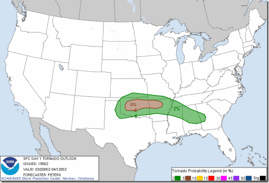
I’m getting ready to get out of here for a bit and see what develops. The SPC has released another outlook, expanding the risk for tornado area. This has got to be one of the strangest set-ups I’ve seen in a while.
I’ll keep you posted throughout the evening.
5:23 PM
I’m still in Tulsa. I know. This look like it’s going to be a late thing. I’ll see how it goes. Right now there’s not much on radar and it’s much more comfortable to sit in my living room than it is to sit in a truck seat on a dirt road somewhere.
7:06 PM
Well, we’re a little over an hour from sunset and tornado watches have been issued to our east. Nothing’s really developed yet. The severe storms are probably going to initiate after sunset. That’s too bad. I don’t like chasing solo at night – it’s just too dangerous. So, I’m going to call it off for today.
It has been interesting, and educational, trying to figure out what this mess was going to do. It’s been a tough one to call. I guess there’s “next time”.
I’ll still be keeping an eye on things until bedtime and if something does pop up locally, I’ll follow it.
11:25 PM
WWUS64 KTSA 040425
WCNTSA
WATCH COUNTY NOTIFICATION FOR WATCH 350
NATIONAL WEATHER SERVICE TULSA OK
1125 PM CDT SUN JUN 3 2012
ARC007-015-033-047-087-131-143-OKC001-021-035-037-041-061-079-091-
097-101-105-111-113-115-117-131-135-143-145-147-041200-
/O.NEW.KTSA.SV.A.0350.120604T0425Z-120604T1200Z/
THE NATIONAL WEATHER SERVICE HAS ISSUED SEVERE THUNDERSTORM WATCH 350 IN EFFECT UNTIL 7 AM CDT MONDAY FOR THE FOLLOWING AREAS
IN ARKANSAS THIS WATCH INCLUDES 7 COUNTIES
IN NORTHWEST ARKANSAS
BENTON CARROLL CRAWFORD
MADISON WASHINGTON
IN WEST CENTRAL ARKANSAS
FRANKLIN SEBASTIAN
IN OKLAHOMA THIS WATCH INCLUDES 20 COUNTIES
IN EAST CENTRAL OKLAHOMA
CHEROKEE MUSKOGEE
SEQUOYAH
IN NORTHEAST OKLAHOMA
ADAIR CRAIG CREEK
DELAWARE MAYES NOWATA
OKMULGEE OSAGE OTTAWA
PAWNEE ROGERS TULSA
WAGONER WASHINGTON
IN SOUTHEAST OKLAHOMA
HASKELL LE FLORE MCINTOSH
THIS INCLUDES THE CITIES OF…BARTLESVILLE…BENTONVILLE…
BERRYVILLE…BRISTOW…CHARLESTON…CLAREMORE…EUFAULA…
EUREKA SPRINGS…FAYETTEVILLE…FORT SMITH…HUNTSVILLE…JAY… MIAMI…MUSKOGEE…NOWATA…OKMULGEE…OZARK…PAWHUSKA…
PAWNEE…POTEAU…PRYOR…ROGERS…SALLISAW…SPRINGDALE…
STIGLER…STILWELL…TAHLEQUAH…TULSA…VAN BUREN…
VINITA AND WAGONER.
1:59 AM Monday
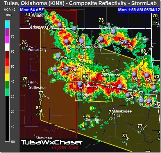
The storms are here. Finally.
I ran out to roll the window up on my truck…wow!
1:30 AM
WUUS54 KTSA 040637
SVRTSA
OKC037-113-131-143-145-040730-
/O.NEW.KTSA.SV.W.0121.120604T0637Z-120604T0730Z/
BULLETIN – EAS ACTIVATION REQUESTED
SEVERE THUNDERSTORM WARNING
NATIONAL WEATHER SERVICE TULSA OK
137 AM CDT MON JUN 4 2012
THE NATIONAL WEATHER SERVICE IN TULSA HAS ISSUED A
* SEVERE THUNDERSTORM WARNING FOR…
EASTERN CREEK COUNTY IN NORTHEAST OKLAHOMA
SOUTHEASTERN OSAGE COUNTY IN NORTHEAST OKLAHOMA
SOUTHERN ROGERS COUNTY IN NORTHEAST OKLAHOMA
TULSA COUNTY IN NORTHEAST OKLAHOMA
WESTERN WAGONER COUNTY IN NORTHEAST OKLAHOMA
* UNTIL 230 AM CDT
* AT 134 AM CDT…SEVERE THUNDERSTORMS WERE LOCATED ALONG A LINE EXTENDING FROM 4 MILES NORTH OF SAND SPRINGS TO 5 MILES NORTHEAST OF ONETA…MOVING SOUTHEAST AT 25 MPH.
STORM HAZARDS INCLUDE…
WIND GUSTS TO 60 MPH…
* SOME LOCATIONS IN OR NEAR THE PATH OF THESE STORMS INCLUDE…SANDSPRINGS…BROKEN ARROW…ONETA…TULSA…SAPULPA…COWETA…JENKS…KIEFER…PORTER…GLENPOOL…BIXBY…MOUNDS AND STONEBLUFF.
THIS INCLUDES INTERSTATE 44 BETWEEN MILE MARKERS 210 AND 248.
PRECAUTIONARY/PREPAREDNESS ACTIONS…
THIS STORM HAS A HISTORY OF PRODUCING DAMAGING WINDS. SEEK SHELTER IMMEDIATELY INSIDE A STURDY STRUCTURE AND STAY AWAY FROM WINDOWS. MOBILE HOMES AND HIGH PROFILE VEHICLES ARE ESPECIALLY SUSCEPTIBLE TO HIGH WINDS AND MAY BE OVERTURNED.
2:53 AM
We remain under a severe thunderstorm watch and flood warning until 7 and 8 am, respectively.
3:11 AM
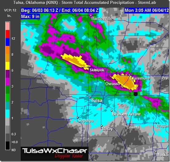
Total rainfall amounts? Around 10” of rain has fallen SW of Claremore. Flooding will be an issue.
And…there’s more coming.
3:55 AM
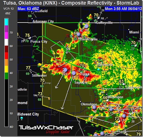
Moderate to heavy rainfall continues in the Tulsa area. Local street flooding is being reported. Skiatook residents are reporting house flooding, and there’s another storm heading their way. It’s been a long night and it’s not over yet.
4:21 AM
Light to moderate rainfall continues in the Tulsa area, however the heavy stuff has moved to the south. Another line of storms has developed to the north. Hopefully they’ll move to the east and away from the areas that are already flooding.
Rain is expected to end by around 7 AM.
5:00 AM
It’s slowing down. Time to get ready for work. Gawd I’m going to regret this night.
Have a great day!

