10:46 pm
The warning for Tulsa has been canceled. it’s moving to the east. I think I’m going to call it a night and listen to it rain.
Thanks for following me tonight. There’s another round possible this weekend.
G’night.
10:28 pm
The Tulsa tornado warning has been extended until 11:00 pm. Now includes Rogers and Wagoner counties.
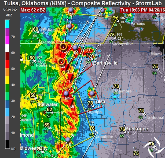
10:00 pm
BULLETIN – EAS ACTIVATION REQUESTED
TORNADO WARNING
NATIONAL WEATHER SERVICE TULSA OK
1000 PM CDT TUE APR 26 2016
THE NATIONAL WEATHER SERVICE IN TULSA HAS ISSUED A
* TORNADO WARNING FOR…
SOUTHEASTERN OSAGE COUNTY IN NORTHEASTERN OKLAHOMA…
SOUTHEASTERN PAWNEE COUNTY IN NORTHEASTERN OKLAHOMA…
NORTHEASTERN CREEK COUNTY IN NORTHEASTERN OKLAHOMA…
CENTRAL TULSA COUNTY IN NORTHEASTERN OKLAHOMA…
* UNTIL 1030 PM CDT
* AT 1000 PM CDT…SEVERE THUNDERSTORMS WITH STRONG LOW LEVEL ROTATION
THAT COULD PRODUCE TORNADOES AT ANY TIME WERE LOCATED ALONG A LINE
EXTENDING FROM 2 MILES NORTHWEST OF WESTPORT TO 2 MILES SOUTH OF
KELLYVILLE…MOVING NORTHEAST AT 55 MPH.
HAZARD…TORNADO.
SOURCE…RADAR INDICATED ROTATION.
IMPACT…FLYING DEBRIS WILL BE DANGEROUS TO THOSE CAUGHT WITHOUT
SHELTER. MOBILE HOMES WILL BE DAMAGED OR DESTROYED.
DAMAGE TO ROOFS…WINDOWS…AND VEHICLES WILL OCCUR. TREE
DAMAGE IS LIKELY.
* LOCATIONS IN OR NEAR THE PATH INCLUDE…
TULSA… BROKEN ARROW…
SAND SPRINGS… BIXBY…
SAPULPA… JENKS…
GLENPOOL… SKIATOOK…
MANNFORD… SPERRY…
KELLYVILLE… WESTPORT…
TURLEY… WALNUT CREEK STATE PARK…
KEYSTONE STATE PARK… GRAY…
THIS INCLUDES INTERSTATE 44 BETWEEN MILE MARKERS 199 AND 228.
PRECAUTIONARY/PREPAREDNESS ACTIONS…
TAKE COVER NOW! MOVE TO A BASEMENT OR AN INTERIOR ROOM ON THE LOWEST
FLOOR OF A STURDY BUILDING. AVOID WINDOWS. IF YOU ARE OUTDOORS…IN A
MOBILE HOME…OR IN A VEHICLE…MOVE TO THE CLOSEST SUBSTANTIAL SHELTER
AND PROTECT YOURSELF FROM FLYING DEBRIS.
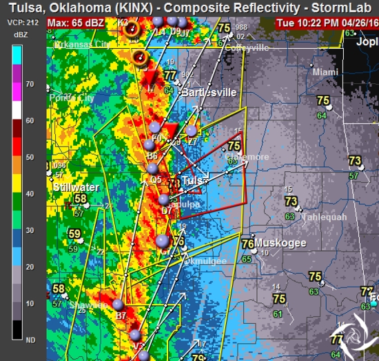
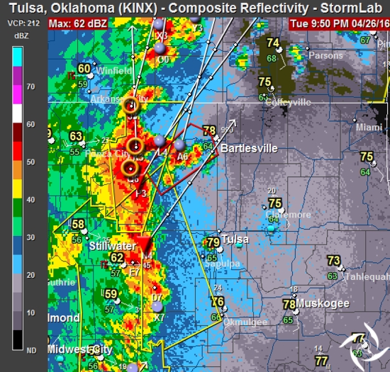
9:50 pm
Back in Tulsa. I traveled 280.6 miles to chase 2 storms. Both storms joined the large line of thunderstorms, making them impossible to chase any longer.
The storms have been slowly moving to the east towards Tulsa. A tornado warning has been issued for Osage county, in effect until 10:15.
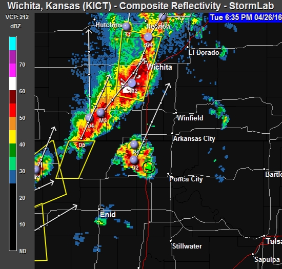
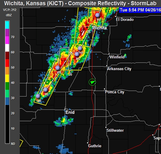
6:38 pm
I’m on this storm. Just rain and wind right now.
5:50 pm
I’m in Blackwell, Oklahoma. The storms aren’t isolated and have merged into a long line of “stuff”.
I’ve stopped for some dinner and will plan my next move.
12:00 noon
The area of concern is growing.
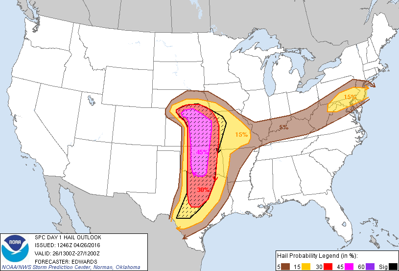
9:00 am
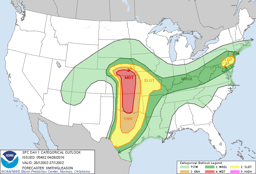
The NWS has identified the significant risk areas for both tornadoes and hail. As you can see in this graphic, this is going to be a wide-spread hail producer.
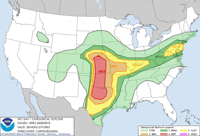
7:00 am
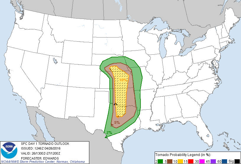
Not much has changed since yesterday. The NWS graphic shows basically the same area of concern, stretching from Nebraska to Texas. It’s a good idea to be “weather aware” today if you’re in or near the projected area. I’m expecting the information to tighten up through the day.
I spent last night getting ready for today. I’ll be chasing this afternoon into the early evening and I hope you’ll be along for the ride. I’ll post here when I have something important to relay. You can also follow my Twitter feed for more immediate posts. As well, when there’s something worth seeing, I’ll stream live from the field.
Be safe.