
I was asked several times today, “Why didn’t you go chasing?”. Well, I did. Kind of. I tracked the storms from the beginning to the end. Here’s the timeline of the two day weather event.
Saturday morning I checked the forecast for the day. A slight chance of rain and thunderstorms was in the forecast. Nothing major. I went about my day doing some things around the house. My normal Saturday routine.
Saturday, 11:32 a.m.
I checked the outlook again just before lunchtime. Again, nothing major was mentioned. A chance of rain and a greater risk to the north of Tulsa.
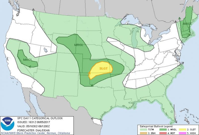
The tornado risk was very low and not something most chasers would even consider going after.
In the discussion, this is how they described the development:
…some supercell structures capable of producing downburst winds and hail as activity develops southeast into the evening. A somewhat better supercell environment with perhaps the risk of a tornado or two might evolve in vicinity of outflow boundary over eastern KS, but is conditional upon sufficient recovery within the cold pool.
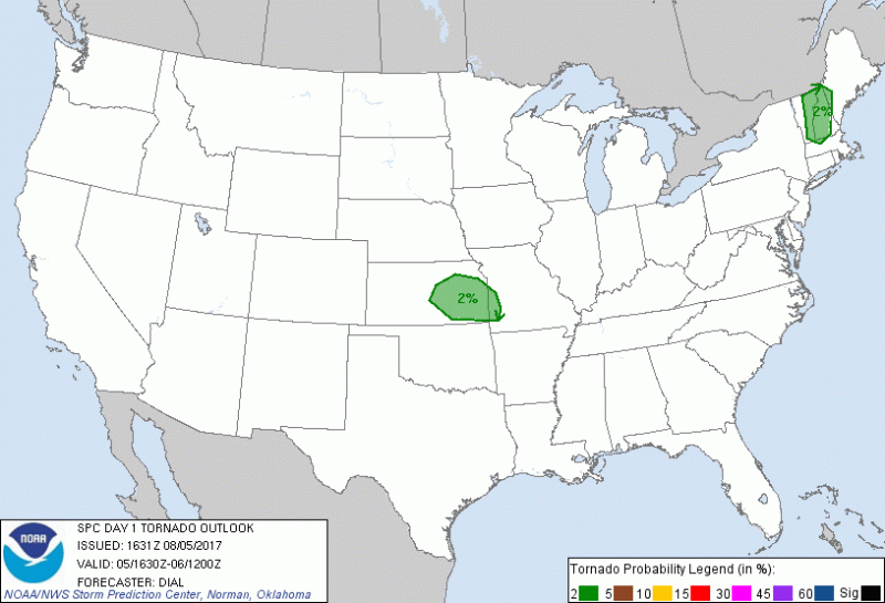
There was a “slight” risk of tornado development over eastern KS, but it wasn’t something that was a certainty, and not worth venturing into Kansas.
You can read the entire outlook here.
Saturday, 3:27 p.m.
The Storm Prediction Center issued Mesoscale Discussion #1449. In that discussion, it basically said there was a chance that a Severe Thunderstorm watch would be issued later today. It covered most of Oklahoma and Kansas.
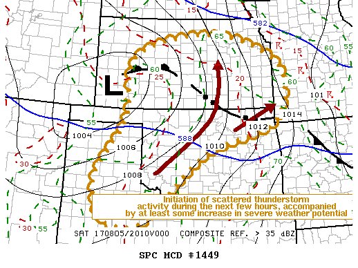
The chance of a watch being issued was 40%. Not a major announcement and we wouldn’t really know the target area until later. The models I use for forecasting put the chances of a watch in southern Kansas.
I watched a movie on the television.
You can read the entire discussion here.
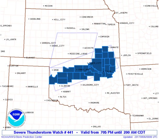
Saturday, 4:08 p.m.
Severe Thunderstorm Watch #440 was issued at 4:08 p.m. As you can see, it included southcentral Kansas and northern Oklahoma. Tulsa was not included in the watch.
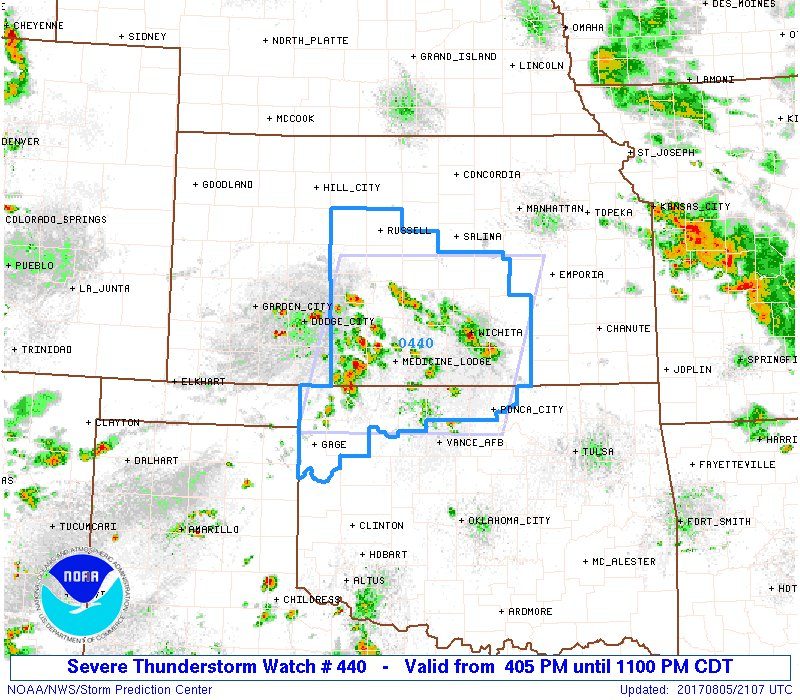
Storms were beginning to develop in southern Kansas and a few in northwest Oklahoma. Nothing dangerous though.
Saturday, 4:22 p.m.
I posted this comment at 4:22 p.m.
We could have some thunderstorms and heavy rains tonight. Flash Flood Watch remains in effect until 1pm on Sunday.
— Tim (@TulsaWxChaser) August 5, 2017
I wasn’t seeing anything that concerned me, but I wanted to relay what the NWS was reporting.
A short time later, John Haverfield, a channel 2 meteorologist, posted this:
Get ready for storms overnight!
Time frame: 12am-8am
Threats: Quarter size hail, 60mph winds, heavy rain. #okwx pic.twitter.com/pdKYKAmvMY— Jon Haverfield (@JonDopplerWX) August 5, 2017
Saturday, 7:10 p.m.
Severe Thunderstorm Watch #441 was issued at 7:00 p.m. I sent the post at 7:10. At this point, I was still thinking we’d get rain and thunderstorms; maybe some hail.
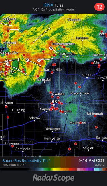
Saturday, 9:00 p.m.
I began looking at the radar at 9:00. Yes, my PC radar was down (service provider server??). So, I used the radar on my phone.
The storms that were developing were north of Tulsa. Still nothing in our area to worry about.
At 9:14, I took this screen capture of the radar. Thunderstorms to the north and moving to the southeast towards the Tulsa area.
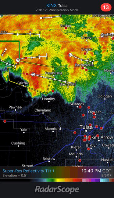
Saturday, 10:40 p.m.
I continued watching the radar and the storms were still staying to the north.
I ran to the grocery store.
Sunday, 12:15 a.m.
I checked the radar again and read the latest NWS bulletins. Rain was beginning to move into Tulsa.
I put the coffee on. I knew it was going to be a late night.
Sunday, 1:09 a.m.
The National Weather Service in Tulsa issued a Severe Thunderstorm Warning for the Tulsa area, valid until 2:15 am.
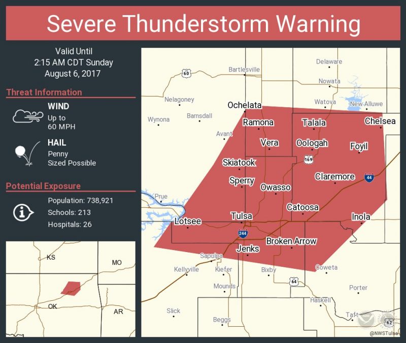
A simple thunderstorm scenario was going to change abruptly.
I began drinking coffee. Lots of it.
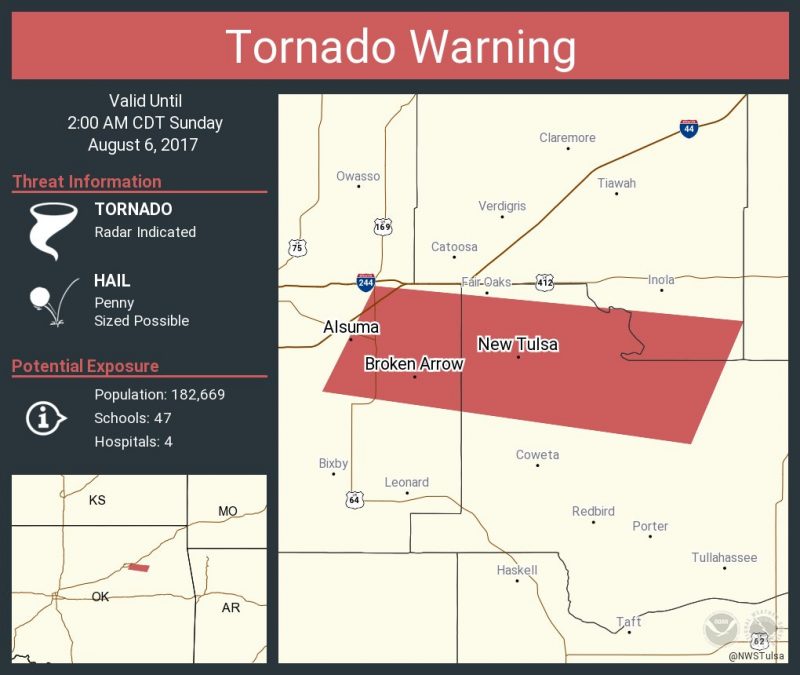
Sunday, 1:25 a.m.
The National Weather Service issued a Tornado Warning for Tulsa. What the fuck?
Immediately following the issuance of the warning, I posted this comment. I think I was a little surprised.
Well…this got interesting quickly.
— Tim (@TulsaWxChaser) August 6, 2017
Little did we know that the first tornado had actually touched down at 1:19 am, 6 minutes before the warning was issued.
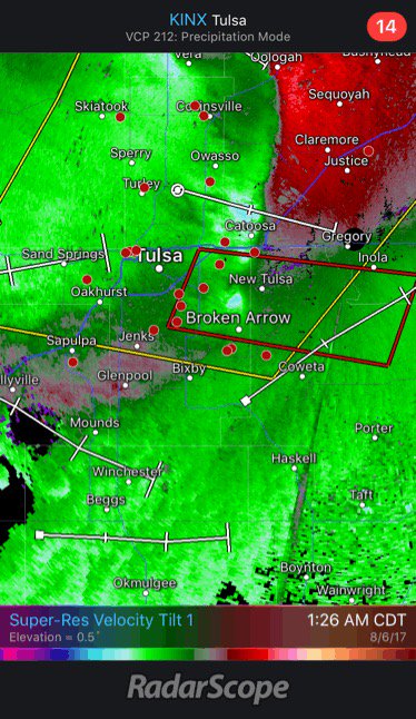
I grabbed this velocity image at 1:26. It showed what appears to be a tornado, now north of Broken Arrow. This was the ending of tornado #1. On the ground for 6 minutes.
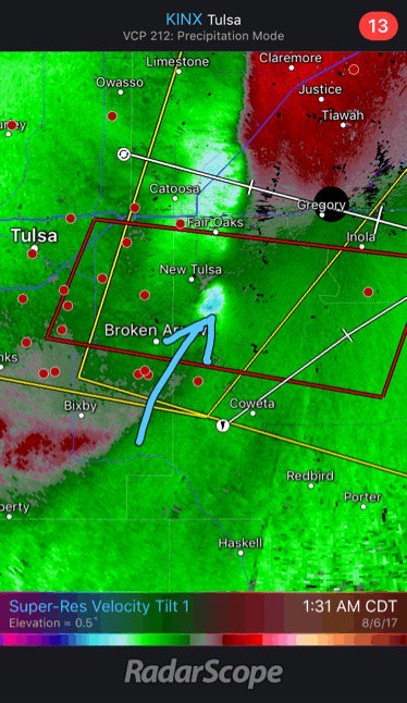
5 minutes later, tornado #2 formed. You can see the tornado the arrow points to. It was now northeast of Broken Arrow. Yes, the storm was moving that fast. This tornado was on the ground for 4 minutes.
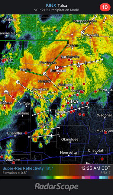
Sunday, 1:37 p.m.
The National Weather Service issued another Tornado Warning for the Oologah area.
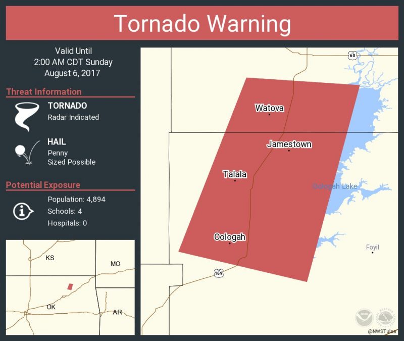
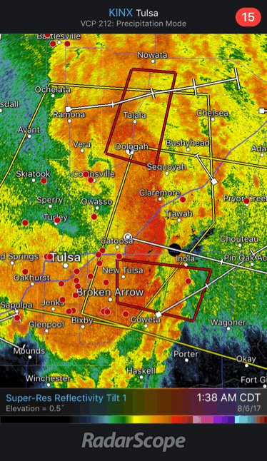
At 1:38 pm the radar was indicating a squall line with both warnings shown.
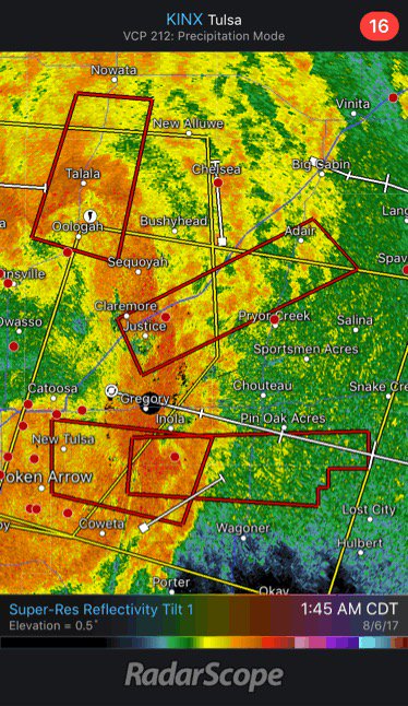
And at 1:45 am, there were 4 warnings in effect.
As I usually do, I had been listening to the police and fire scanner while checking bulletins and the radar. I began hearing chatter about a sign down on I-44 at 41st street. Then the chatter included sending ambulances to 41st and Yale.
The Oklahoma Highway Patrol posted this statement at 1:45 pm. The date was wrong in the post. It was actually the 6th.
I44 at 41st and Sheridan is closed with a large overhead sign that fell down onto the highway 08/05/2017 at 145 hours gdh
— Okla. Highway Patrol (@OHPtraffic) August 6, 2017
Sunday, 2:00 a.m.
The tornado warning for Tulsa had expired by 2:03 am. All warnings expired by 2:28 am.
But, the night wasn’t over. Damage and injury reports began to come in. It was confirmed: a tornado had touched down between Yale and Memorial on 41st street. Two dozen people were transported to local hospitals.
The Tulsa Fire Department posted this at 4:20 am showing some of the damage. Of course, the total scope of the destruction wouldn’t be known until after sunrise.
More Storm Damage pictures. #tfd #tulsa #918 #stormdamage pic.twitter.com/M3OgtdiZqo
— Tulsa Fire Dept. (@TulsaFire) August 6, 2017
I went to bed.
Sunday, 9:00 a.m.
After a pot of coffee, I began looking at all of the damage photographs taken. This one, from Channel 8 reporter Maureen Wortz, shows the damage at TGI Fridays. It took a direct hit and two of the most seriously wounded were in the restaurant when it hit.
Storm damage in Tulsa near 41 and I44 @KTULNews #okwx pic.twitter.com/pj4QZn8ecZ
— Maureen Wurtz (@MaureenWurtzTV) August 6, 2017
This one, from Amy Slanchik, Channel 6, shows aerial views of the damage.
Some incredible pictures of the damage from today’s tornado in Tulsa, from Jeff Gouin. The @NWStulsa confirms EF2 intensity. #okwx pic.twitter.com/EXnbofM0xh
— Amy Slanchik (@amyslanchik) August 6, 2017
Dozens of photographs were posted throughout the day. I’m not going to post all of them here. If you want to see more of them, I’ve got several in my twitter feed.
Sunday, 11:58 p.m.
The National Weather Service confirmed 3 tornadoes. The one at 41st and Yale was an EF2 with estimated peak winds of 120-130 mph. They confirmed 26 injuries. Most of the destruction was between Yale and Sheridan on 41st street.
Here’s the complete post-mortem from the NWS.
[gview file=”https://www.tulsawxchaser.com/blog/wp-content/uploads/2017/08/2017-0706-tornado-report-from-the-nws.pdf”]
Monday, 10:22 p.m.
Here’s a few things I’ve learned this evening:
- 41st street between Yale and Sheridan remains closed and may be closed for several days.
- 10 businesses have been condemned by the City of Tulsa engineers. Dozens of businesses and houses were damaged.
- Looting of the AT&T store happened shortly after the tornado hit.
- Over 10,000 customers were without power following the tornado. As of now, 35 customers are still without power.
- Mayor Bynum is addressing why there was no warning before the first tornado hit and why the sirens weren’t activated.
- There may have been a 4th tornado. The NWS may update their report.
This video from KOCO in OKC shows the devastation: