
It was a LONG day for sure. I left the house at 12 noon and arrived back home at 12 midnight after covering 554 miles.
The tornado watch issued was for SE Colorado, SW Kansas and NW Oklahoma. I decided to venture towards the panhandle.
The closer I got to Woodward, it was obvious that I’d missed the target. The watch for that area had been canceled.
At that point, I wasn’t far from Freedom – my Dad’s birthplace – so I made the decision to check it out.
Freedom is a very small town with a two-block mainstreet. I didn’t stop, but now I wish I had. Next time I’m near there I will.
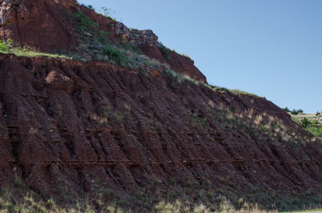
Just south of Freedom is the Cimarron River and her banks are lined with gypsum bluffs. Pretty awesome sight. Seeing them makes me want to spend a couple of days traveling to the far west edge of the panhandle to visit the Black Mesa. Maybe in the fall I will.
I pulled off on the highway, south of the river, and grabbed my camera for the first time on this trip. I stopped a couple more times further south on highway 50 to take in some of the scenery and to marvel at the vast reaches of the landscape.
I finally found one developing storm moving into NW Oklahoma from the Texas panhandle. It moved VERY slowly to the east-northeast (about 30 mph) cycling up and down the whole time. After tracking it for a couple of hours, I knew intercepting it was doubtful – even if the storm stayed together until I could.
As it’s been the last couple of times, the really active storms were south of Oklahoma City. My choices were to wait for the Texas storm, that hadn’t even crossed highway 33 yet, go south into an area that is dangerous to chase in, or head back to Tulsa. Once I got to highway 51, I decided to call it and head east.
It was a good day though. I saw some country I’d not seen before. I’d visited the city where my Dad was born, and I made a few photographs along the way.
To view the photo album, click here.

6:47 PM
I’ve worked hard today to stay out of the OKC area. I’m in Seiling, OK waiting for a few minutes to see if this storm that’s developing to the SW is going to stay together by the time it gets close. We’ll see. If that doesn’t work out, I’ll head back towards Tulsa to see what trouble I can get into.
___
8:04 AM
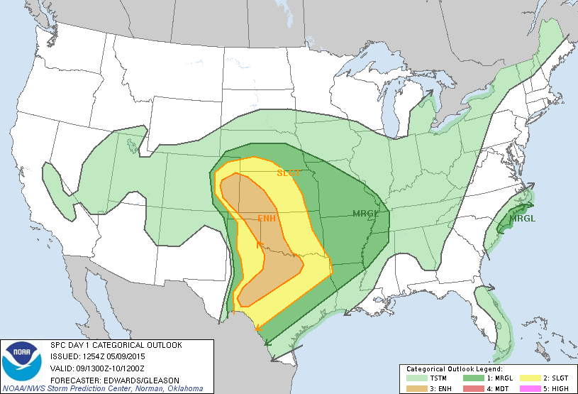
Models are being updated and the moderate risk area identified earlier this morning is gone. There’s still an enhanced risk, with SW Kansas being the target area. I’m going to head out in a bit and head west. I’ll pinpoint the target area later today.
___
7:50 AM
It’s not the best setup I’ve seen. But, I guess we have to take what we can get.
The dryline is at the Oklahoma panhandle and should advance to the east through the day, and the front will be moving south. The best chances will be in southwest Kansas for late this afternoon. But, a line of storms will move through this area this morning could work the atmosphere over, taking the punch out of evening development. The question I ask myself is, “will it recover in time?”
I woke up at 4 a.m. to review the models and found them to be less than impressive. Disappointing. So, I went back to bed.
Back up at 7 a.m. and now I’m waiting for another update.