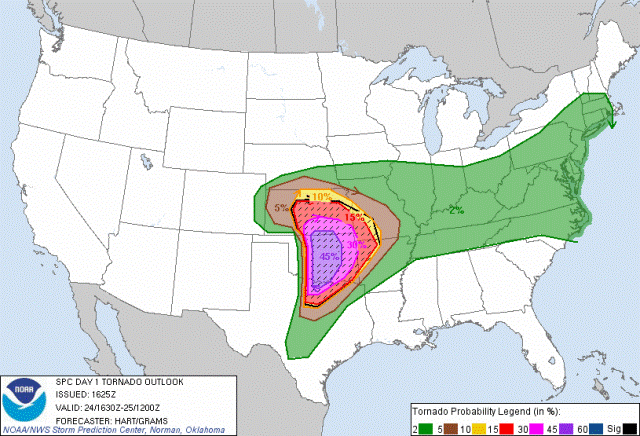
11:00 PM: If you were following our twitter feed, you know that we picked the spot for a tornado: Guthrie, OK. The tornado formed west of us and tracked right towards our location. We moved and the tornado adjusted, again moving towards us. We moved again and once again, we were in the path.
We ended up driving north of Stillwater as the storm headed towards them. We rode it out on the side of the road. Once it passed south of us, we got back on it and chased it towards Tulsa. Fortunately, it stopped producing tornadoes, turning to rain, small hail and strong winds.
Unfortunately, the southern storms we went after killed 5 people and destroyed dozens of homes before it dissipated. Our prayers are with the families of those affected.
As many of you found out, we had some issues with our live video stream from the field. By the time we got to Tulsa we figured out that the router and the 2 modems were causing a problem. We direct-connected my modem to the PC and the stream began working. A little late for streaming our adventure today. Isolating the problem will help us on the next chase.
Each time we go out, we learn something new. Today was no different.
We were thankful that today wasn’t as bad as it could have been. We’re also thankful that we weren’t added to the list of fatalities. Being on our game saved our butts for sure. We made the right moves and stayed clear of a killer.
This system is moving east tonight, but it’s not going to stop. We could see a few thunderstorms tomorrow here in the Tulsa area, but it doesn’t appear they’ll be severe. However, expect severe weather east of Oklahoma tomorrow as this system continues. No we’re not going to chase tomorrow. I think we’re going to take a few days off.
3:14PM: We are staging west of Guthrie. 3 tornado warnings have been issued to our west. Southern storm should be the one in play.
1:47 PM: PDS Tornado Watch has been issued for much of W and C OK, effective until 10pm. This is a dangerous situation.
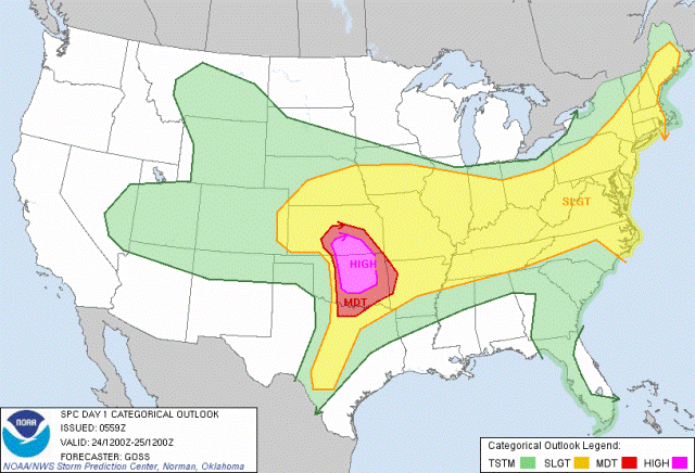
11:30 PM: The National Weather Service expanded the high risk area and included this statement:
“…AN INTENSE OUTBREAK OF TORNADOES AND WIDESPREAD SEVERE
THUNDERSTORMS IS EXPECTED LATER TODAY OVER PORTIONS OF KS/OK/TX…”
Enough said about that.

11:09 PM: Getting ready to leave. I’ve got a bad feeling about today. Everyone: Please be prepared for this afternoon/evening. Models are all supporting a major weather event.
5:43 AM: This is a new Hazardous Weather Outlook for the Tulsa area:
HAZARDOUS WEATHER OUTLOOK
NATIONAL WEATHER SERVICE TULSA OK
517 AM CDT TUE MAY 24 2011
ARZ001-002-010-011-019-020-029-OKZ049-053>076-251000-
ADAIR OK-BENTON AR-CARROLL AR-CHEROKEE OK-CHOCTAW OK-CRAIG OK-
CRAWFORD AR-CREEK OK-DELAWARE OK-FRANKLIN AR-HASKELL OK-LATIMER OK-
LE FLORE OK-MADISON AR-MAYES OK-MCINTOSH OK-MUSKOGEE OK-NOWATA OK-
OKFUSKEE OK-OKMULGEE OK-OSAGE OK-OTTAWA OK-PAWNEE OK-PITTSBURG OK-
PUSHMATAHA OK-ROGERS OK-SEBASTIAN AR-SEQUOYAH OK-TULSA OK-WAGONER OK-
WASHINGTON OK-WASHINGTON AR-
517 AM CDT TUE MAY 24 2011
…OUTBREAK OF TORNADOES…SOME STRONG AND LONG TRACKED…LATE
THIS AFTERNOON AND EVENING…
…DANGEROUS FLOODING ONGOING…
THIS OUTLOOK IS FOR NORTHWEST AND WEST CENTRAL ARKANSAS AS WELL AS
MUCH OF EASTERN OKLAHOMA.
.DAY ONE…TODAY AND TONIGHT.
TORNADO.
RISK…SIGNIFICANT.
AREA…ALL OF EASTERN OKLAHOMA AND NORTHWEST AND WEST CENTRAL ARKANSAS.
ONSET…AFTER 4 PM.
AREA AT GREATEST RISK…NORTHEAST OKLAHOMA AND FAR NORTHWEST ARKANSAS.
SEVERE THUNDERSTORM.
RISK…CRITICAL.
AREA…ALL OF EASTERN OKLAHOMA AND NORTHWEST AND WEST CENTRAL ARKANSAS.
ONSET…AFTERNOON.
FLASH FLOOD.
RISK…ELEVATED.
AREA…NORTHEAST OKLAHOMA AND NORTHWEST AND WEST CENTRAL ARKANSAS.
ONSET…AFTERNOON.
SIGNIFICANT WINDS.
RISK…LIMITED.
AREA…ALL OF EASTERN OKLAHOMA AND NORTHWEST AND WEST CENTRAL ARKANSAS.
ONSET…ONGOING.
DISCUSSION…
A WIDESPREAD…AND POTENTIALLY LIFE THREATENING…SEVERE WEATHER
EPISODE IS EXPECTED THIS AFTERNOON AND EVENING ACROSS EASTERN
OKLAHOMA AND NORTHWEST ARKANSAS. THE DEVELOPING WEATHER PATTERN IS
HIGHLY FAVORABLE FOR LONG TRACK SUPERCELLS CAPABLE OF STRONG OR
EVEN VIOLENT TORNADOES…SOFTBALL SIZE HAIL…AND WINDS IN EXCESS
OF 70 MPH. THESE STORMS WILL DEVELOP ACROSS CENTRAL OKLAHOMA LATE
THIS AFTERNOON AND SPREAD EASTWARD DURING THE EVENING.
A FEW THUNDERSTORMS WILL CONTINUE THIS MORNING ALONG A STATIONARY
FRONTAL BOUNDARY STRETCHING FROM NORTH CENTRAL OKLAHOMA INTO WEST
CENTRAL ARKANSAS. THESE STORMS WILL POSE A LIMITED THREAT FOR
SMALL HAIL THROUGH THE MORNING.
BY LATE THIS AFTERNOON…A STRONG UPPER LEVEL SYSTEM WILL BE
MOVING OUT OF THE SOUTHWEST U.S. WITH AN EXTREMELY UNSTABLE
AIRMASS IN PLACE OVER MUCH OF CENTRAL AND EASTERN OKLAHOMA.
SCATTERED THUNDERSTORMS ARE EXPECTED TO DEVELOP ALONG THE DRY LINE
IN CENTRAL OKLAHOMA LATE THIS AFTERNOON AND BECOME SEVERE VERY
QUICKLY. FORECAST WIND PROFILES ARE EXTREMELY FAVORABLE FOR LONG
LIVED SUPERCELLS CAPABLE OF PRODUCING TORNADOES. STORMS WILL
INCREASE IN COVERAGE THROUGH THE EVENING AS THEY MOVE INTO
NORTHWEST ARKANSAS WITH THE THREAT OF WIDESPREAD DAMAGING SEVERE
WEATHER CONTINUING LATE INTO THE EVENING.
A CRITICAL FACTOR IN DETERMINING THE AREA OF HIGHEST TORNADO
POTENTIAL WILL BE THE LOCATION OF A SURFACE FRONTAL BOUNDARY…
WHICH WILL MOST LIKELY RESIDE OVER NORTHEAST OKLAHOMA AND FAR
NORTHWEST ARKANSAS BY EARLY THIS EVENING. A THUNDERSTORM COMPLEX
MOVING OVER KANSAS THIS MORNING MAY PUSH THE BOUNDARY FARTHER TO
THE SOUTH AND IF THIS HAPPENS… THE HIGHEST RISK AREA MAY NEED TO
BE SHIFTED SOUTH WITH LATER UPDATES.
IN ADDITION…DANGEROUS FLOODING REMAINS ONGOING OVER PARTS OF
NORTHEAST OKLAHOMA AND NORTHWEST ARKANSAS DUE TO HEAVY RAINFALL
MONDAY. ANY ADDITIONAL SIGNIFICANT RAIN WILL ONLY ENHANCE THE
FLOODING ISSUES.
SPOTTER AND EMERGENCY MANAGEMENT ACTION STATEMENT…
ACTIVATION OF THE REGIONAL SPOTTER NETWORK EXPECTED BY LATE THIS
AFTERNOON AND WILL LIKELY BE NEEDED THROUGH LATE THIS EVENING.
EMERGENCY MANAGERS SHOULD PREPARE FOR A HIGH-END SEVERE WEATHER
EVENT…INCLUDING THE POSSIBILITY OF RESCUE AND RECOVERY EFFORTS.
.DAYS TWO THROUGH SEVEN…WEDNESDAY THROUGH MONDAY.
WEDNESDAY…THUNDERSTORM POTENTIAL…HIGH WIND POTENTIAL.
THURSDAY…NO HAZARDS.
FRIDAY…THUNDERSTORM POTENTIAL.
SATURDAY…THUNDERSTORM POTENTIAL.
SUNDAY…NO HAZARDS.
MONDAY…HIGH WIND POTENTIAL.
EXTENDED DISCUSSION…
THE UPPER LOW WILL CONTINUE TO MOVE EAST AND BRING MORE
THUNDERSTORM POTENTIAL WEDNESDAY…WITH A LIMITED THREAT FOR SEVERE
THUNDERSTORMS ACROSS MAINLY NORTHWEST ARKANSAS. THE NEXT CHANCE OF
STORMS AFTER THAT WILL BE FRIDAY NIGHT INTO SATURDAY…BUT AT THIS
TIME THE SEVERE WEATHER POTENTIAL LOOKS LIMITED. ONGOING RIVER
FLOODING WILL LIKELY CONTINUE THROUGH MUCH OF THE WEEK.
4:52 AM: Yeah, it’s early morning. While most are sleeping comfortably, I’m checking the MD and the various models. Today WILL be a chase day.
If this develops like we think it’s going to, today could be a dangerous situation. Everyone in Oklahoma should be keeping close watch on developing weather conditions. Make certain your weather radio has fresh batteries, a survival kit is ready and your shelter-in-place plans are prepared.
The NWS has issued a high risk forecast for today. The likelyhood of seeing severe weather is pretty good. Long tracking tornadoes is a possibility too.

