

11:42PM Update – NWS Statement
SPECIAL WEATHER STATEMENT
NATIONAL WEATHER SERVICE TULSA OK
944 PM CST SUN DEC 1 2013…WINTRY WEATHER EXPECTED LATER THIS WEEK…
VERY COLD AIR WILL MOVE INTO EASTERN OKLAHOMA AND NORTHWEST
ARKANSAS ON WEDNESDAY AND REMAIN IN PLACE INTO THE WEEKEND.
AT THE SAME TIME SEVERAL UPPER-LEVEL DISTURBANCES WILL CROSS THE
REGION BRINGING PERIODS OF WINTRY WEATHER. SNOW…SLEET AND
FREEZING RAIN WILL OCCUR WITH ACCUMULATIONS EXPECTED. THIS WILL
LEAD TO TRAVEL IMPACTS STARTING LATE WEDNESDAY NIGHT AND
CONTINUING INTO SATURDAY MORNING THAT WILL EVENTUALLY AFFECT MUCH
OF THE AREA. IN ADDITION… SOME UTILITY INTERRUPTIONS COULD OCCUR
WHERE THE HEAVIER FREEZING RAIN FALLS.VERY COLD AIR WILL COMBINE WITH NORTH WINDS TO PRODUCE WIND
CHILLS BELOW ZERO IN PARTS OF THE AREA ON FRIDAY AND SATURDAY.WHILE THE POTENTIAL FOR THIS WINTRY WEATHER IS STILL SEVERAL DAYS
AWAY… IT WOULD BE A GOOD IDEA TO TAKE ADVANTAGE OF THE MILDER
WEATHER ON MONDAY AND TUESDAY TO COMPLETE ANY OUTDOOR WORK AND TO
MAKE INITIAL PREPARATIONS FOR THE TURN IN THE WEATHER.IF CONFIDENCE INCREASE THAT SIGNIFICANT IMPACTS WILL OCCUR… A
WINTER STORM WATCH WILL BE ISSUED. UNTIL THEN… ALL INTERESTS IN
EASTERN OKLAHOMA AND NORTHWEST ARKANSAS SHOULD MONITOR THE LATEST
FORECASTS.
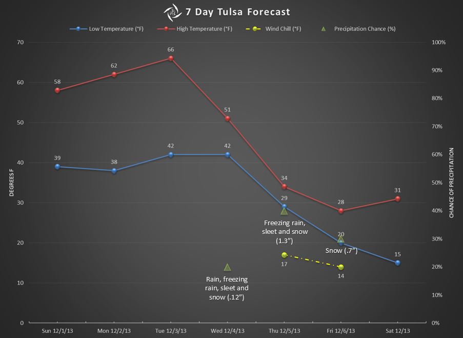
Here in Tulsa, we missed out on the last round of winter weather. Don’t give up. Another round will push through Oklahoma beginning mid-week, and there’s a good chance that Tulsa will get a glimpse of Old Man Winter this time.
The next couple of days gives us an opportunity to prepare for any winter weather that comes our way. It’ll be dry with daytime high temps in the 50s and 60s. Overnight lows are expected to be near 40°.
The pleasantry will change as a cold front moves through the area Wednesday night. Temperatures will drop into the upper 20s overnight and we’ll have our first chance for a wintry mix of rain, freezing rain, sleet and snow.
Bitterly cold temperatures will be upon us by Thursday and continue on Friday. Daytime temps will only reach into the low 30s and the lows will drop into the 20s. We could get down into the mid-teens early Saturday morning.
Along with the cold temperatures, we could find ourselves under a blanket of ice and snow, accumulating 1/4″ of ice and nearly 2″ of snow. Unfortunately the ice will likely come first.
Keep this in mind: forecasting winter weather this far in advance is a crap shoot. The timing of the front and the type of precipitation we get will surely change dozens of times before it finally gets here. But, confidence is relatively high that we’ll see some kind of frozen stuff towards the end of the week.
We have an opportunity, though, to prepare for a couple days of slick driving conditions. You know the routine.
- Stock up on 2 or 3 days of food, water and medications
- Fill your vehicle with fuel
- Have a supply of salt or other material to treat your sidewalks
- Make sure you have a safe alternate heat source
Here’s the forecast Graphic for the week.
I’ll post an update when we get closer and the forecast becomes more accurate.
I forgot about Bedlam next weekend. It’s going to be cold in Stillwater when OU faces off against OSU. If you’re going to the game, dress warm.