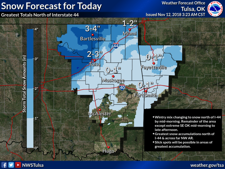
At 1:41 this morning, the snow accumulation forecast was updated. We could see 2 to 3 inches of the white stuff today. The timing has changed too. We should see mainly snow falling after 9 am.
The best chances of snow accumulation will be along and north of Interstate 44 in Oklahoma and across far northwest Arkansas. Up to 4 inches of snow will be possible primarily on grassy areas and elevated surfaces with some locally higher amounts possible as well. There may be some slick spots on bridges on Monday.
Sunday, November 11
At 1:59 pm today, the NWS issued a Winter Weather Advisory for much of NE Oklahoma, including Tulsa. It’s in effect from 3 am until 6 pm on Monday. In Tulsa, it looks like the snowfall will begin between 3 am and 7 am, although that could change.
The latest graphic from the NWS is showing more snow than the earlier forecast.
The best chances of snow accumulation will be along and north of Interstate 44 in Oklahoma and across far northwest Arkansas. Up to 2 inches of snow will be possible primarily on grassy areas and elevated surfaces with some locally higher amounts possible as well. There may be some slick spots on bridges on Monday.
If you thought it was still a mild autumn, think again. There’s a little winter in the forecast beginning overnight, tonight. If you have to travel out of the area over the period, check forecasts and road conditions before you leave.
NWS. A wintry mix of rain and snow is likely late Sunday night into Monday across portions of eastern Oklahoma and northwest Arkansas. The best chances of snow accumulation will be along and north of Interstate 44 in Oklahoma and across far northwest Arkansas. Up to 2 inches of snow will be possible primarily on grassy areas and elevated surfaces.. There may be some slick spots on bridges on Monday.