

2/11/2024, 4:00pm update
The forecast area and forecast have been updated. Up to 4″ of now accumulation is possible in the Tulsa area.
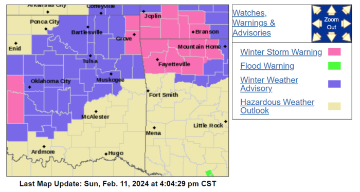
URGENT – WINTER WEATHER MESSAGE National Weather Service Tulsa OK 1253 PM CST Sun Feb 11 2024 OKZ054>057-059>062-064>071-121100- /O.CON.KTSA.WW.Y.0007.240212T0300Z-240212T1800Z/ Osage-Washington OK-Nowata-Craig-Pawnee-Tulsa-Rogers-Mayes-Creek- Okfuskee-Okmulgee-Wagoner-Cherokee-Adair-Muskogee-McIntosh- Including the cities of Pawhuska, Bartlesville, Nowata, Vinita, Pawnee, Tulsa, Claremore, Pryor, Sapulpa, Okemah, Okmulgee, Wagoner, Tahlequah, Stilwell, Muskogee, and Checotah
1253 PM CST Sun Feb 11 2024 …WINTER WEATHER ADVISORY REMAINS IN EFFECT FROM 9 PM THIS EVENING TO NOON CST MONDAY…
WHAT…Snow expected. Total snow accumulations of 1 to 4 inches.
WHERE…Portions of east central, northeast and southeast Oklahoma.
WHEN…From 9 PM this evening to noon CST Monday.
IMPACTS…Plan on slippery road conditions while the moderate to heavy snow is occurring. The snow is expected to impact the Monday morning commute in some areas. Melting is expected to occur once the snow tapers off, making travel less difficult.
PRECAUTIONARY/PREPAREDNESS ACTIONS… Slow down and use caution while traveling. For the latest road conditions call 1-844-465-4997 or go to okRoads.org. && $$ Stay tuned to NOAA weather radio,commercial radio or television for the latest information,forecasts,and warnings. For more information from the National Weather Service visit https://weather.gov/tsa
Hazardous Weather Outlook
Hazardous Weather Outlook National Weather Service Tulsa OK 1247 PM CST Sun Feb 11 2024 ARZ001-002-010-011-019-020-029-OKZ049-053>076-121130- Adair OK-Benton AR-Carroll AR-Cherokee OK-Choctaw OK-Craig OK- Crawford AR-Creek OK-Delaware OK-Franklin AR-Haskell OK-Latimer OK- Le Flore OK-Madison AR-Mayes OK-McIntosh OK-Muskogee OK-Nowata OK- Okfuskee OK-Okmulgee OK-Osage OK-Ottawa OK-Pawnee OK-Pittsburg OK- Pushmataha OK-Rogers OK-Sebastian AR-Sequoyah OK-Tulsa OK-Wagoner OK- Washington OK-Washington AR- 1247 PM CST Sun Feb 11 2024 This Outlook is for Northwest and West Central Arkansas as well as much of Eastern Oklahoma. .DAY ONE…This Afternoon and Tonight. THUNDERSTORMS WITH DANGEROUS LIGHTNING. RISK…Limited. AREA…Far Southeast Oklahoma. ONSET…Ongoing. WINTER WEATHER. SNOW ACCUMULATION. RISK…Limited. AREA…Northeast Oklahoma and Northwest Arkansas. ONSET…Late this Evening. Additional Accumulations in Later Periods. SIGNIFICANT WINDS. RISK…Limited. AREA…Eastern Oklahoma and Western Arkansas. ONSET…Ongoing. DISCUSSION… Light rain continues across much of the area this afternoon, with a few rumbles of thunder still possible near the Red River through the afternoon. Gusty northeast winds will also continue this afternoon and evening as a potent storm system moves into the region. By this evening, a transition to wet snow is likely as a potent upper low moves across southeast Oklahoma. Given marginal temperature profiles, snow accumulations will be largely be determined by the exact track of the passing storm system and any mesoscale banding that occurs. This may lead to varying snow amounts with updated forecasts. At this time, accumulations generally of one to three inches are forecast primarily near the Interstate 44 corridor in northeast Oklahoma into northwest northwest Arkansas, primarily on grassy or elevated surfaces. A corridor of higher snowfall is becoming increasingly likely across far northeast Oklahoma and northwest Arkansas where heavier banding is likely to occur. Snow totals of four plus inches will be possible in this zone through the duration of the storm. SPOTTER AND EMERGENCY MANAGEMENT ACTION STATEMENT… Spotter Activation Not Expected. .DAYS TWO THROUGH SEVEN…Monday through Saturday. MONDAY…Winter Weather Potential…High Wind Potential. TUESDAY…No Hazards. WEDNESDAY…High Wind Potential. THURSDAY…No Hazards. FRIDAY…Thunderstorm Potential…High Wind Potential. SATURDAY…High Wind Potential. EXTENDED DISCUSSION… Snow and rain will taper off Monday morning, but some lingering heavier snow is possible across far northeast Oklahoma and northwest Arkansas. Any travel impacts that may develop should be limited to late tonight into the Monday morning commute as temperatures quickly warm above freezing. Dry and warmer weather is expected through mid week. weather.gov/tulsa contains additional information.
URGENT – WINTER WEATHER MESSAGE National Weather Service Tulsa OK 226 PM CST Sat Feb 10 2024 ARZ001-002-010-011-OKZ057-058-060>070-110430- /O.NEW.KTSA.WW.Y.0007.240212T0300Z-240212T1800Z/
Benton-Carroll-Washington AR-Madison-Craig-Ottawa-Tulsa-Rogers- Mayes-Delaware-Creek-Okfuskee-Okmulgee-Wagoner-Cherokee-Adair- Muskogee- Including the cities of Rogers, Bentonville, Berryville, Eureka Springs, Fayetteville, Springdale, Huntsville, Vinita, Miami, Tulsa, Claremore, Pryor, Grove, Jay, Sapulpa, Okemah, Okmulgee, Wagoner, Tahlequah, Stilwell, and Muskogee 226 PM CST Sat
Feb 10 2024 …WINTER WEATHER ADVISORY IN EFFECT FROM 9 PM SUNDAY TO NOON CST MONDAY…
* WHAT…Wet snow expected. Total snow accumulations of up to two inches. * WHERE…Portions of northwest Arkansas and east central and northeast Oklahoma. * WHEN…From 9 PM Sunday to noon CST Monday. *
IMPACTS…Plan on slippery road conditions. The hazardous conditions could impact the morning commute. * ADDITIONAL DETAILS…Potential for heavy snow falling during the morning commute Monday, which could limit visibility and create slushy travel conditions.
PRECAUTIONARY/PREPAREDNESS ACTIONS… Slow down and use caution while traveling. In Arkansas, for the latest road conditions call 1-800-245- 1672 or go to idrivearkansas.com. In Oklahoma, for the latest road conditions call 1-844-465-4997 or go to okRoads.org.