I’ll update this post as soon as I get time. :)
1:30 pm: A Tornado Watch has been issued for several counties this afternoon in central and eastern Oklahoma, effective until 9pm.
WATCH COUNTY NOTIFICATION FOR WATCH 325
NATIONAL WEATHER SERVICE TULSA OK
127 PM CDT SUN MAY 22 2011
ARC007-015-033-047-087-131-143-OKC001-021-023-035-037-041-061-077-
079-091-097-101-105-107-111-113-115-117-121-127-131-135-143-145-
147-230200-
/O.NEW.KTSA.TO.A.0325.110522T1827Z-110523T0200Z/
THE NATIONAL WEATHER SERVICE HAS ISSUED TORNADO WATCH 325 IN
EFFECT UNTIL 9 PM CDT THIS EVENING FOR THE FOLLOWING AREAS
IN ARKANSAS THIS WATCH INCLUDES 7 COUNTIES
IN NORTHWEST ARKANSAS
BENTON CARROLL CRAWFORD
MADISON WASHINGTON
IN WEST CENTRAL ARKANSAS
FRANKLIN SEBASTIAN
IN OKLAHOMA THIS WATCH INCLUDES 25 COUNTIES
IN EAST CENTRAL OKLAHOMA
CHEROKEE MUSKOGEE OKFUSKEE
SEQUOYAH
IN NORTHEAST OKLAHOMA
ADAIR CRAIG CREEK
DELAWARE MAYES NOWATA
OKMULGEE OSAGE OTTAWA
PAWNEE ROGERS TULSA
WAGONER WASHINGTON
IN SOUTHEAST OKLAHOMA
CHOCTAW HASKELL LATIMER
LE FLORE MCINTOSH PITTSBURG
PUSHMATAHA
THIS INCLUDES THE CITIES OF…ANTLERS…BARTLESVILLE…
BENTONVILLE…BERRYVILLE…BRISTOW…CHARLESTON…CLAREMORE…
CLAYTON…EUFAULA…EUREKA SPRINGS…FAYETTEVILLE…FORT SMITH…
HUGO…HUNTSVILLE…JAY…MCALESTER…MIAMI…MUSKOGEE…NOWATA…
OKEMAH…OKMULGEE…OZARK…PAWHUSKA…PAWNEE…POTEAU…PRYOR…
ROGERS…SALLISAW…SPRINGDALE…STIGLER…STILWELL…TAHLEQUAH…
TULSA…VAN BUREN…VINITA…WAGONER AND WILBURTON.
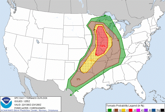
1:00 pm: The models are still indicating a good chance of severe weather this afternoon, into the evening hours. We have an elevated risk for tornadoes in region 1 (NE). Storms should begin firing as the dryline approaches the area. Inititation should take place after 3pm, although timing is uncertain. It could be a little later. I just spoke to Justin and he’s going to be here at 3 to head out. Updating our chase status to Active.
11:00 am: I’m looking at the forecasts and models and it appears we could be in for a bumpy ride today. Moderate risk for severe weather, including tornadoes, for this afternoon. Most likely target area will probably be far NE OK into SE KS. I’m not sure if we’re going to go hunting today, but I’ll keep an eye on what’s happening in the area. If we do chase today, we may not have far to go.

