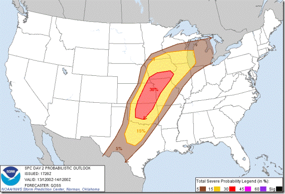
I’ve looked at the models this evening and it appears that a wide area of severe weather is likely for at least 5 states, including Oklahoma. Right now the area is so large, pin-pointing the target area most likely to produce storms worth chasing is nearly impossible. That task will need wait until Saturday morning.
The risks tomorrow afternoon and evening are more typical of springtime storms: heavy rain, damaging winds, hail and the possibility of tornadoes. Temps are expected to warm to near 80° with dew points in the 60s and strong winds.
This is what the National Weather Service is saying about tomorrow:
BANDS OF STRONG TO SEVERE STORMS WILL MOVE INTO NORTHEAST OKLAHOMA BY LATE SATURDAY AFTERNOON…AND INTO NORTHWEST ARKANSAS DURING THE EVENING HOURS. THERE IS AN ELEVATED RISK OF HAIL TO 2 INCHES IN DIAMETER AND SWATHS OF DAMAGING WINDS TO 70 MPH IN THE STRONGER BOW SEGMENTS. ISOLATED TORNADOES WILL ALSO BE POSSIBLE WITH ANY CELLS THAT SEPARATE FROM THE LINEAR CONVECTION. HEAVY RAINFALL WILL ALSO BE LIKELY ALONG WITH A FLASH FLOOD THREAT IN PARTS OF NORTHEAST OKLAHOMA AND NORTHWEST ARKANSAS WHICH SAW SIGNIFICANT RAINFALL FRIDAY MORNING.
I’ll update again in the morning after I look at what has taken place overnight. At this point, it looks like I’ll be out there for a fall chase.

